 |
|

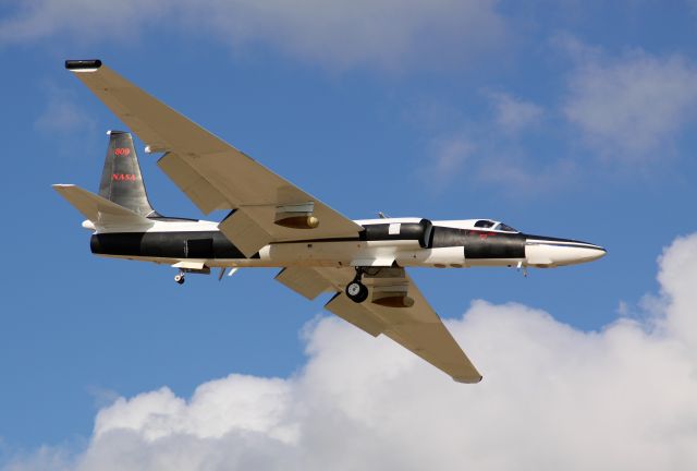
Lockheed ER-2 (NASA809)
A derivative of the U-2 Dragon Lady, NASAs ER-2 (Earth Resources -2) is a high altitude sensor aircraft. N809NA or "NASA809" is assigned to the Dryden Flight Research Center on Edwards AFB, California and is based at the Dryden Aircraft Operations Facility hangar in Palmdale, California. It used for top-down, edge of space imaging and atmospheric sampling of Earth resources, disaster assessment, celestial observations, as well as oceanic processes and trending. According to the ER-2 Handbook, Powered by a single jet engine, the ER-2 carries a single pilot and up to 2,550 lb of payload to altitudes approaching 70,000 ft. Typical ER-2 missions last 6.5 hours and cover a range of 2,200 nm. It is possible to accomplish missions of up to 8 hr duration ranging to 3,000 nm. The nose, cockpit, optional wing pods, and Q-bay, just aft of the cockpit are all pressurized and climate controlled. There are other payload areas available, including the E-bay, wing tips, centerline pylon, and tail cone. The nose and Q-bays tandem windows have 16 inch glass with heaters to defeat condensation at altitude. The windows can be replaced by plates that will allow sensor probes that require access to the outside of the pressure vessel. For added situational awareness for the pilot, a small remotely controlled camera gimbal is mounted on the belly of the ER-2, just under the cockpit. This Optical View Sight is used to see what is underneath the aircraft while in level flight. NASA 809 has been deployed to Ellington Field in Houston to fly sorties to record and assess the effects of British Petroleums MC252 Deepwater Horizon explosion and subsequent oil spill on the Gulf of Mexico. The ER-2 was tasked with these overflights to utilize the highly specialized AVIRIS Airborne Visible Infrared Imaging Spectrometer imaging, a 224 band hyper-spectral scanner designed by the Jet Propulsion Laboratory in Pasadena, California. The AVIRIS system is an 800 lb unit mounted in the Q-bay. In addition to the scanners imaging, regular photographs are obtained by the nose mounted Hasselblad camera with digital back, utilizing a Zeiss lens and a Tiffen yellow filter. To service the camera, the nose removes completely from the airframe with 4 quick release latches.
Comments
|
활동 로그
1998년까지 거슬러 가는 NASA809에 대한 완전한 이력 검색을 원하십니까? 지금 구매하세요. 1시간 이내에 구하십시오.
|
| 날짜 | 항공기 | 출발지 | 행선지 | 출발 | 도착 | 비행시간 |
|---|---|---|---|---|---|---|
| 2024년 4월 23일 | U2 | Edwards Afb (KEDW) | Edwards Afb (KEDW) | 09:36 PDT | 15:29 PDT | 5:52 |
| 2024년 4월 17일 | U2 | Edwards Afb (KEDW) | Edwards Afb (KEDW) | 10:21 PDT | 16:46 PDT | 6:24 |
| 2024년 4월 16일 | U2 | Edwards Afb (KEDW) | Edwards Afb (KEDW) | 10:00 PDT | 16:24 PDT | 6:23 |
| 2024년 4월 11일 | U2 | Edwards Afb (KEDW) | Edwards Afb (KEDW) | 10:06 PDT | 16:20 PDT | 6:14 |
| 2024년 4월 10일 | U2 | Edwards Afb (KEDW) | Edwards Afb (KEDW) | 09:58 PDT | 15:30 PDT | 5:32 |
| 기본 사용자 (기본 사용자가 되는 것은 무료이고 쉽습니다!) 3 months 이력 보기. 참여 | ||||||
Please log in or register to post a comment.